Interior Dept Using Drones for Research, Wildfires
Drone Fleet Supports Modern Approach to Managing Wildfire and Natural Resources on Public Lands
BOISE, Idaho – With a fleet of 312 unmanned aircraft, the Department of the Interior’s (DOI) Office of Aviation Services flew nearly 5,000 missions in 2017 to support everything from fighting wildfires to monitoring dams and spillways and mapping wildlife. The accomplishments of its unmanned aerial systems (UAS), or drone program, can be found in a report announced today by DOI that summarizes flights made by more than 200 certified pilots in 32 states nationwide.
Drone flights to support natural resource management across DOI, including support to firefighters suppressing wildfires, increased 82 percent from 2016 to 2017. The report breaks down the flights for more than 1,000 projects by agency, geographic area, and missions for wildfire and non-wildfire purposes.
“Interior is committed to preventing the spread of catastrophic wildfires through smarter and more aggressive practices and tactics,” said U.S. Secretary of the Interior Ryan Zinke. “I had the opportunity to join our wildfire professionals last year and was able to test some of the technology that is now being used. After seeing the capabilities, I know it will continue to make a big difference in firefighting. The UAS program is a perfect example of leveraging technology to fight fires in safer and more efficient ways to ensure we are protecting the men and women on the fire line, members of the public, and local communities. Coupled with more aggressive fuels management, this technology will help prevent and control catastrophic wildfires.”
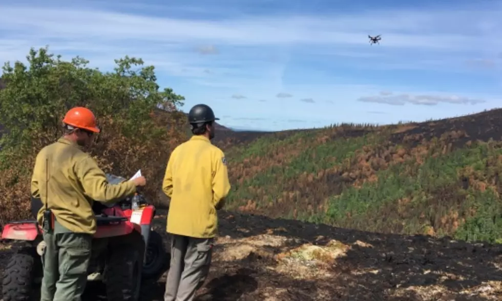
This past fire season, DOI conducted 707 drone missions on 71 individual wildfires. Drones were used by firefighters to gain a tactical advantage on wildfires by allowing them to improve their surveillance and reconnaissance capabilities. The data and information gathered during these flights was used to support strategic planning for fighting wildfires. These advancements support the safety of our firefighters and the public through the detection of hotspots, improved mapping, and advanced monitoring of wildfires.
“The Department of the Interior has worked hard to build a UAS program that is a leader in non-Department of Defense applications,” said Deputy Assistant Secretary for Public Safety, Resource Protection, and Emergency Services Harry Humbert. “This technology opens limitless possibilities for resource managers. The Department is proud of the collaboration that uses technology to support wildland fire and natural resource management more safely and more efficiently than ever before.”
The program started flying missions in 2010 with 208 flights. The aircraft are fitted with video cameras, infrared heat sensors, and other equipment that instantly deliver high resolution images. The DOI unmanned fleet includes 3DR Solo Quadcopters and Pulse Vapor 55TM Helicopters. The newest addition, a Hybrid VTOL Fixed-Wing, joins the fleet in early 2018.
Over the past seven years, DOI has seen drones accomplish missions faster and cheaper than traditional aviation.
“We’ve helped DOI programs accomplish their goals for an average of one-tenth of the cost in one-seventh the time of traditional means,” said Jeff Rupert, Acting Director of the Office of Wildland Fire. “Adding drone support to fire suppression efforts could dramatically reduce the size and cost of wildfires, potentially saving millions of dollars and hundreds of thousands of acres with triple the hours of critical aviation support.”
Mark Bathrick, Director of the Office of Aviation Services, sees the increasing use of drones as a chance to improve safety and efficiency of land and resource management. “We are always looking for ways to improve safety,” said Bathrick. “Aviation accidents have been the leading cause of fatalities among field biologists. Increasing the use of UAS or drones can increase safety for certain missions. Drones can also instantly deliver high quality data for a fraction of the cost of traditional flights.”
The next stage of the Department’s UAS program starts soon with the testing of a new class of drones to assist in fire suppression and fuels management. Scheduled for field trials later this spring, the new drones could assist firefighters with prescribed fires and with suppressing operations, especially during times when traditional firefighting aircraft can’t fly due to smoky conditions.
Beginning in 2016, the DOI provided wildfire location data to private drone operators to prevent interference with firefighting operations. With system updates in 2017 the public now has access to location data for fires reported by DOI and the U.S. Forest Service within the last eight days in Alaska, Texas, Wyoming, North Dakota, and California via the GeoPlatform ArcGIS Online.
More than 4,200 of the DOI drone flights provided broad support to DOI lands and resources. Drone aircraft fitted with wide ranging sensors helped with inspection of dams and wells, wildlife surveys, monitoring of illegal dumping, and land mapping.
More From K96 FM